Japan’s five easiest-to-get-lost-on mountain trails are like alpine brain teasers【Photos】

Data analysis highlights where hikers are most likely to get a little too far off the beaten path.
As an island nation, Japan has plenty of beaches that people flock to in the summer, but the country’s mountains are a popular destination for outdoorsy types too. Especially now that we’re out of the rainy season, more and more people are going to be hitting the hiking trails, but there’s one thing to watch out for: some mountains are really, really easy to get lost on.
Japanese hiking app Yamap (a mashup of “yama,” the Japanese word for “mountain,” and “map”) recently finished an analysis of its user submitted data, sifting through which mountain trails had been most marked as easy to get lost on as well as which of those warnings were rated as the most useful by others. From that, they put together a list of the five most confusing, easiest-to-get-lost spots on mountain trails in Japan, so let’s take a look at the results, and maybe take some notes, so that we don’t get lost ourselves.
1. Kakamigahara Alps Gongenyama – Kiriyazaka (Gifu Prefecture)

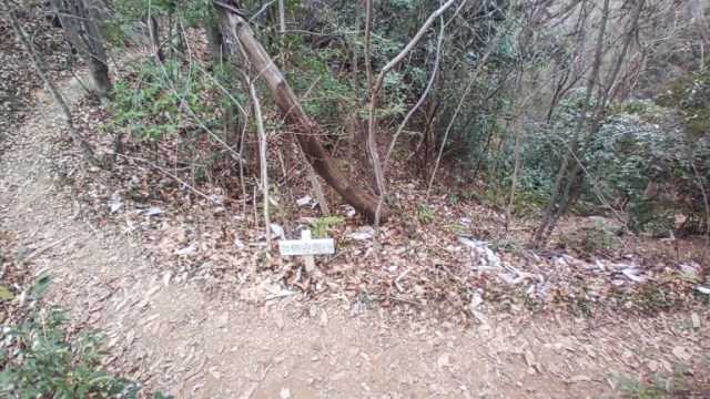
Out of the top five, this spot on the Gongenyama-to-Kiriyazaka route is the only one where you’ll see a sign. That sign looks to be lower than knee-high, though, with only some small, faded lettering letting you know that you need to go right for the walking trail to Kiriyazaka. Head left, and the trail will dead end as the mountain goes vertical for a full-on climbing section.
2. Tenkakusan – Aganonoatama (Saitama Prefecture)

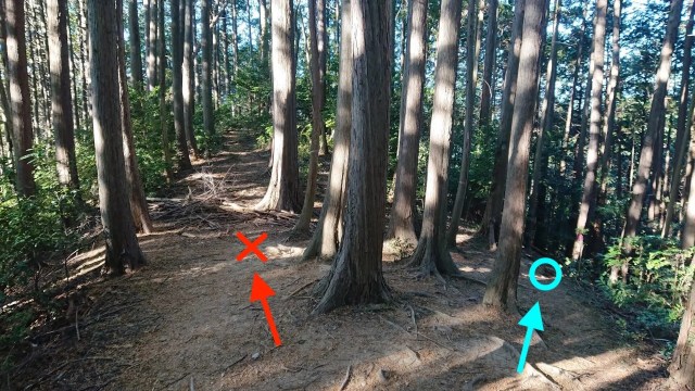
OK, no more signs from here on out! This Saitama trail gets pretty counterintuitive this spot where continuing on the nice flat, broad path to the left leads you to the steep edge of the mountain. Instead, you want to veer right, down that narrow section where your feet will temporarily be at a 45-degree angle. Why no sign here? Apparently the pink tape wrapped around that one tree trunk (just to the right of the blue circle added to the photo) is supposed to be enough to guide you in the right direction.
3. Nenogongen – Mutsuishinoatama (Saitama Prefecture)

Now there’s not even marking tape, but if you want to make it to the end of the trail, you need to hang a left at this seemingly random spot.
4. Gozaishodake – Buheitoge (Shiga and Mie Prefectures)

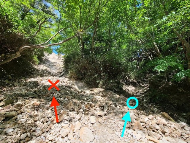
Once again, you pretty much have to go against all your instincts here. The left-side path of least resistance will eventually meet up with the rest of the trail, but it’s a steep, slippery incline that’ not officially part of the route, whereas the easier-to-navigate, but harder-to-notice, path on the left is the one you’re supposed to go on.
5. Takahatayama – Nakanosawanoatama (Saitama Prefecture)

And last, here we’ve at least got two clearly identifiable paths, but no indication as to which one we’re supposed to take. In this case, right is right, as taking the left path will send you off course.
Obviously, part of Yamap’s goal in releasing these rankings is to encourage people to use their app so that they don’t get lost, but they also hope to encourage local forestry services to add clearer trail markings at these points. Yamap put together a similar ranking last year, and says that increased signage resulted in no cases of lost hikers on those trails. For the time being, though, it’s probably a good idea to make sure your phone has a full charge before you hit the trails, not just so that you can take pictures, but so that you can check your location too.
Related: Yamap
Source, images: PR Times
● Want to hear about SoraNews24’s latest articles as soon as they’re published? Follow us on Facebook and Twitter!
Credit:

0 comments: